I'm sharing a file of the location of all railway stations in Great Britain, put together from Table 1410 of the UK's Office of Rail and Road (ORR). So, clearly, a momentous occasion. I published something similar years ago and I see people still using it but the old one doesn't have new stations like Reston, Inverness Airport or Marsh Barton in it. Oh, and I also calculated the nearest station (as the crow flies) for each station, just out of curiosity. Here's the spreadsheet.
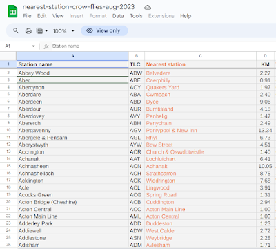 |
| The real blockbuster of the summer |
I posted a few maps I made of this on my twitter, as a kind of annoying map quiz - these are copied below too. What on earth are these maps showing? Well, for each of the 2,573 stations in my dataset I simply drew a line to its nearest station. Sometimes the lines are reciprocal - e.g. for Aberdeen, Dyce is the nearest station as the crow flies, and for Dyce, Aberdeen is nearest. In these cases the lines on the map look a bit glowy because there are two overlapping each other. But this kind of thing isn't always the case. That's why the maps look kind of disjointed and weird.
Now, if you can't be bothered clicking on to the spreadsheet then here are the numbers on furthest gaps between stations and also nearest to each other according to my calculations. And remember that a) this is straight line distance, as the crow flies, and b) it doesn't mean you can actually travel between these station pairs. It's purely a measure of how far away - in a straight line - the nearest station is.
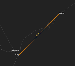
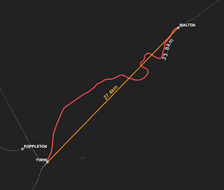
- Malton to York - 27.4 km / 17.0 miles
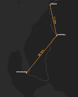
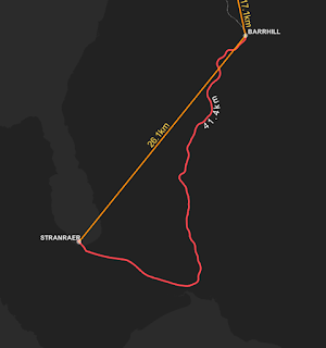
- Stranraer to Barrhill - 26.1 km / 16.2 miles
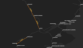
- Wick to Georgemas Junction - 22.2 km / 13.8 miles
and at the bottom of the list
- Catford to Catford Bridge - 0.09 km / 0.06 miles
- Catford Bridge to Catford - 0.09 km / 0.06 miles
- St Budeaux Victoria Road to St Budeaux Ferry Road - 0.12 km / 0.08 miles
Hmm, but what about actual distance along the railway? Could we try and figure this out? Yes we could. But first here's a map or two comparing the longest straight lines to how bendy the real lines are.
 |
| Bendy |
 |
| VERY bendy |
 |
| Surprisingly bendy |
And my quest to find the longest gap between stations - again, regardless of whether you can get a train from one to the other - has led me to the following maps.
 |
| More interesting if you're into this stuff |
 |
| I do believe we have a winner |
 |
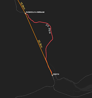
| Not very bendy, so similar distances |
Okay, so, to sum up.
- Some stations are far away from others.
- Some stations are close to others.
- Some stations are even further away if you are a train.
- Malton to York is the 'furthest nearest' station gap at 27.4 km / 17.0 miles
- Stranraer to Barrhill is the 'furthest nearest' station gap if you follow the railway line, at 41.4 km / 25.7 miles.
- Coatbridge Central and Highbury & Islington are both the nearest station - as the crow flies - to four other stations. That's more than any other.
- What about tube stations, tram stops, subway, etc? I'm only looking at the national network of rail stations included in the ORR data here so that's not part of this.
 |
| The clue is in the name! |
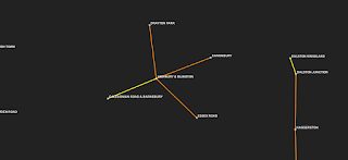 |
| Centre of a universe |
 |
| Another more bendy one |


