
I've recently been looking closely at population density data for Great Britain, Europe and the World. There are a number of good sources of data for this, which typically comes as a 1km resolution grid, including GHSL, the EU, and Datadaptive for Great Britain (based on ONS data). I'm working on some more technical stuff with this data - with varying degrees of success - but I have also outputted a few maps, including stuff I posted on twitter. I just thought I'd share a few of the raw maps here, plus a few observations, because the gifs are a little too quick and small to see the detail. Let's start with the Europe data.
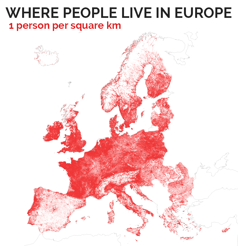 |
| I'm still not 100% convinced that Spain is correct - hmm |
 |
| Pretty similar to the above, but Scandinavia looks most different |
 |
| You can start to pick out settlement patterns more clearly now |
 |
| Now we're getting up to reasonable urban density levels |
 |
| This basically shows the most dense inner cities - Madrid and Paris highest here |
I also did a similar thing for Great Britain, as you can see below. Nothing earth-shattering of course but I find it interesting and I know others do too.
 |
| You can see that lots of 1km cells have no people in them |
 |
| This is isn't much different to the map above, just a little less red |
 |
| Now this is just the wider urban fabric of Great Britain |
 |
| This level of density is major towns and cities |
 |
| Click to enlarge this and you'll see there's more to this than London |
Some observations...
1. For the European data, it seems that Spain stands out as being different and - to the naked eye at least - potentially incorrect. I'm not sure about this though, because the data are collated, quality checked and published by the EU and have been circulated widely. Spain also has some very high urban densities and a notably different settlement pattern to other European nations.
2. Some countries are missing. Yes, this is because the EU data does not include some Balkan states, and other non-EU or non-EAA countries. But the coverage is pretty good and, if we want to do this on a global level then we could use GHSL data.
3. The availability of different data sources measuring the same thing now allows us to compare them and attempt some kind of validation and cross-checking. This is also important because where the 1km grid cells fall can of course affect the numbers reported at the local level.
4. Interestingly, for EU data, the UK is split into its four constituent nations here with separate country codes for EN, NI, SC and WA. The data, from 2011, shows that England is one of the most densely populated nations in Europe on this measure - and with recent growth since 2011 it may be the most densely populated, overall.
5. Using the most recent data I could find (2016 for England and 2017 for the Netherlands), England's population density is 424 persons per square km and in the Netherlands it is 502 (if you see lower figures for NL elsewhere it's probably because it includes non-land area, a common mistake). But raw arithmetic density figures are not that useful in my opinion because many areas have much higher densities and many much lower - in this case the mean is not a good model. A good example of this - at the extreme - is looking at population density in Russia. The fact that it has lots of empty land far from the main population centres could give the impression of a very empty country when in fact this would be a good case for using built-up density. This is something Duncan Smith has done in his excellent World Population Density map (see the Analysis link at the bottom of it).
6. The figures for Great Britain suggest some slightly higher maximum densities at the 1km cell level than the EU data but they are reasonably close. But nowhere in the UK is close to the maximum urban density figures in France and Spain. Both countries have a maximum density figure of above 50,000 per square kilometre. In the UK the maximum is just over 20,000 (in London). Poland, Belgium, Greece, Sweden - among others - all have higher absolute maximum densities than the UK.
7. I think population density is best measured and explored locally, so that's why I'm working with this data. More on that to follow in future hopefully.