Back in 2013 I published a paper in the journal Cities with the following title: 'English urban policy and the return to the city: A decade of growth, 2001–2011'. I actually wrote it in 2012 and it drew upon some of the urban policy things I'd written about in my PhD a few years earlier. If I had access to the paper now, or if I wanted to spend $27.95, I could even read it again but the gist of it was this: people came back to the city centre, in quite big numbers, between 2001 and 2011.
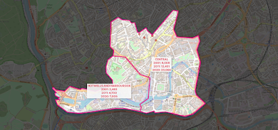
You don't need an academic journal paper to tell you that because you couldn't see it just by walking around, obviously. But really it was about a bit more than population and it discussed New Labour urban policy, the Urban White Paper of 2000 and lots of other stuff. I've also just discovered that it has 61 citations on Google Scholar, which means as many as 61 people were at one point potentially aware of its existence and some might even have read it. Okay, too much preamble, time for a map - showing the population of the central Manchester and Salford wards that more than doubled in population between 2001 and 2020 (I don't have the census data for wards yet).
Why was I thinking about this?
It's because of the release this week of a big wodge of local Census 2021 data for England and Wales. I thought I'd go and look at the changes from 2001 to 2021 but then I couldn't find quite what I was looking for (ward population data) so I went and looked at the mid-year population data for wards instead, and how I find myself writing about it here because it's quite interesting.
If you haven't already spotted these things, three observations from the map above:
- Salford Quays ward had less than 1,000 people living in it in 2001.
- Central Manchester/Salford has the largest collection of contiguous wards (6) in England and Wales that more than doubled in population between 2001 and 2020 - the population now in the six wards above is about 85,000, compared to 24,000 in 2001 and 50,000 in 2011.
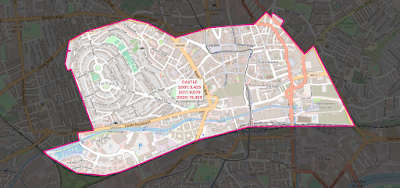
- Deansgate and Piccadilly wards in Manchester look like a rabbit (Piccadilly) getting a piggyback on a goose (Deansgate - see below). This is the unintended consequence of me looking at map data for too long, but it's a clear fact.
 |
| I'm not wrong, am I? |
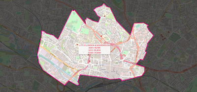
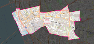
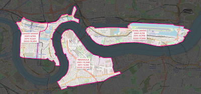
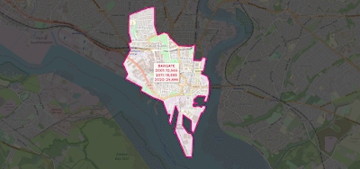
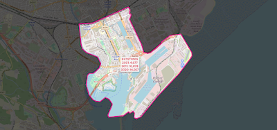
The numbers are of course not surprising if you've ever stepped foot in an English city centre over the past 20 years but it's quite interesting to be able to put a number on things. So now I'll share more maps of different cities, showing the 2001, 2011 and 2020 population data, like I have for central Manchester above (all areas shown more than doubled in population from 2001 to 2020).
 |
| Birmingham |
 |
| Bristol |
 |
| Leeds |
 |
| Leicester |
 |
| Liverpool |
 |
| East London (1) - plus a bit non-East London |
 |
| East London (2) |
 |
| Newcastle |
 |
| Nottingham |
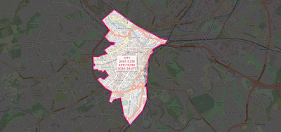 |
| Sheffield - check out those numbers! |
 |
| Southampton |
Who are all these new people? Well, again it's not that hard to fathom if you have been paying any attention but a mix of students in new private sector accommodation, the so-called 'young professionals' estate agents seem to love and a mix of other folk, including some families and whatnot. Could also say stuff about brownfield sites here, as well as New Labour urban policy (the old 60% target) but that doesn't interest me much these days so I'll leave it at that.
Oh, go on then, a few more.
 |
| Cardiff - yes, 100% NOT in England! But interesting |
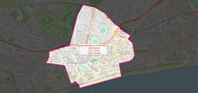 |
| Bournemouth |
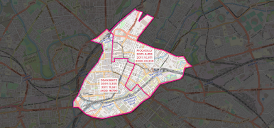 |
| I can't unsee it |
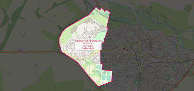 |
| Poundbury |
 |
| This one was missing a label in the version above |


